
ABOUT BAYESMAP
Probabilistic LiDAR processing, built on 20+ years of research.
BayesMap Solutions turns raw point clouds into trustworthy deliverables, and tells you exactly how much you can trust them. Probabilistic processing for airborne and terrestrial laser scanning.
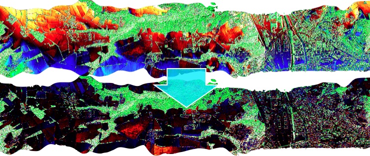
Overlapping strips before (left) and after (right) our probabilistic correction.
20+
Years of Bayesian research
2014
Founded, French SAS since 2023
2
Flagship software products
CNRS
Research scientist founder
OUR APPROACH
We don't just process LiDAR. We model its uncertainty.

Per-point attributes (range uncertainty, target thickness, intensity) computed from the raw waveform.
Model errors, don't hide them
We treat systematic biases as parameters and solve them with Bayesian inference, instead of cutting data to mask them.
Quantify every point
Per-point uncertainty is computed and propagated, so the most accurate points carry the most weight.
Fuse for maximum accuracy
Once swaths are aligned, they combine into the highest-accuracy elevation model your data allows.
Where conventional pipelines hide their errors, we model them, and hand you the map.
The BayesMap philosophy
WHAT WE STAND FOR
Probabilistic by design. Practical by experience.
Quantify uncertainty
We don't hide error. We measure it, and manage it through rigorous error propagation.
Research-grade rigor
Over 20 years of peer-reviewed Bayesian methods, applied to real airborne and terrestrial datasets.
Save real money
Fly higher, cut calibration flights, and keep every point. Better accuracy at lower project cost.
OUR COMPANY
Founded in 2014. French since 2023.
The company
BayesMap Solutions LLC was founded in September 2014 and registered in California, to provide consulting and software development services for the LiDAR industry. We focus on data processing, providing efficient and accurate solutions to challenging problems, and we help our clients extract a maximum of information from large and complex datasets.
As of 1 January 2023, BayesMap is registered as a French SAS and located near Marseille, France. Legal information about the company is on the contact page.
We are committed to conducting a sustainable business and to promoting environmentally friendly practices. Read our environmental policy statement (PDF, 2 pages).
The founder — André Jalobeanu, PhD
André Jalobeanu received his PhD in Engineering and Image Processing from the University of Nice-Sophia Antipolis, France, in 2001, and obtained a permanent research scientist position with CNRS, France, in 2004.
He has been doing research in data processing and analysis — images, signals, time series, point clouds — for more than 20 years. The methods he developed use Bayesian inference, with an emphasis on automation and uncertainty estimation.
RESEARCH & PUBLICATIONS
Expertise built on published work.
Our expertise is data processing using Bayesian inference. Our publications on ResearchGate cover LiDAR data processing, image and signal processing, stereo photogrammetry, data fusion, pan-sharpening, rendering and deconvolution.
AutoProbaDTM — waveform LiDAR
A three-year, $200,000 waveform LiDAR research project, with André Jalobeanu as principal investigator. Funded by FEDER (European Union) and FCT (Portugal), with data provided by IMAO France.
Grants PTDC/EIA-CCO/102669/2008 and FCOMP-01-0124-FEDER-010039.
NPS / DHS earthquake response
LiDAR task: probabilistic change maps, published at SPIE. Run under a Naval Postgraduate School and Department of Homeland Security interagency agreement.
Agreement HSHQDC-10-X-00535/-00002.
TRUSTED ON AIRBORNE & TERRESTRIAL PROJECTS



























FREE EVALUATION
Let's talk about your data.
Send us a sample dataset. We'll process it and show you the accuracy gain, at no cost.